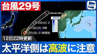


TOKYO - Typhoon No. 29 was moving northward over waters east of Japan at strong intensity as of 10 p.m. on October 12th, with forecasts indicating that the storm will continue moving away from the country and transition into an extratropical cyclone on October 13th, although high waves generated by the typhoon could pose a growing threat along the Pacific coast of northern Japan.
The typhoon has weakened from very strong to strong intensity, with satellite imagery showing changes in its cloud structure. Earlier images had revealed a clearly defined eye near the storm's center, but its outline has become increasingly indistinct as the system gradually loses strength.
Despite the weakening, Typhoon No. 29 continues to maintain an area of storm-force winds around its center. The storm is expected to shift from a northerly to a more northeasterly course, carrying it farther away from the Japanese archipelago.
Forecasters do not expect the rain clouds surrounding the typhoon's center to directly affect Japan. However, ocean swells generated by the storm remain a concern, particularly along the country's eastern coastline.
Wave simulations indicate that seas remain particularly rough near the typhoon's center, while swells approaching from the southeast are continuing to reach parts of Japan's Pacific coast.
Although the storm will move farther offshore through October 13th, some coastal areas of northern Japan are expected to experience stronger swells than on October 12th. The Pacific-facing coastlines of Hokkaido and the Tohoku region are among the areas where wave conditions could deteriorate despite the typhoon's increasing distance.
The risk reflects the ability of ocean swells to travel considerable distances from their source, allowing rough seas to persist or intensify along exposed coastlines even after a storm has moved away.
Residents and visitors along the Pacific coast are being advised to exercise caution near the shoreline and avoid approaching areas exposed to high waves. Particular attention is recommended in northern Japan, where easterly swells could produce increasingly hazardous coastal conditions from October 13th onward.
Typhoon No. 29 is expected to complete its transition into an extratropical cyclone on October 13th as it continues tracking northeastward over the Pacific Ocean.
Source: ウェザーニュース